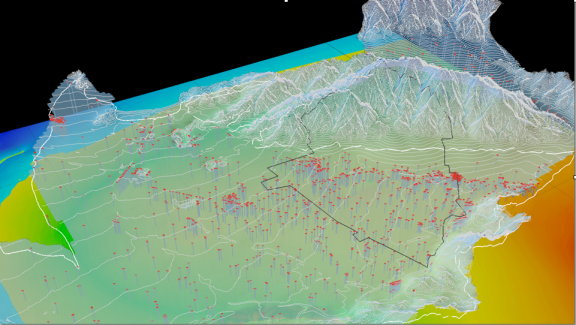
Fall Climate Change Studio: Divining LA

July 15, 2014
Interested in the design of climate adaptation?
Want to develop GIS skills?
Collaborate with researchers and designers across the city?
Help shape the future of LA?
Sign up for these 2 opportunities:
ARCH 691 ALI Studio Fall 2014: Divining LA
Peter Arnold, instructor
T, F 1:00 p.m. – 6:00 p.m
cross-listed with ARCH 489 Design Studio 4B, ARCH 491 Design Studio 5A, and ARCH 491 Graduate Studio 5.
This Fall the Arid Lands Institute offers an intensive graduate-level research studio investigating the role urban fabric and landscape systems play in maximizing LA's last remaining untapped water resource: storm water.
This research studio is open to graduate students in their penultimate semester, and qualified undergraduates (4B/5A).
Led by ALI's Research Director Peter Arnold, the studio will focus on conducting geospatial analysis and performing environmental modeling for the strategic shaping of climate-adapted urbanism in Los Angeles.
Work conducted in the studio is part of the larger public initiative, Divining LA, a collaboration involving public utilities, technical partners from the private sector, and collaborators from other universities. Dialog with public officials and environmental engineers are an integral part of the studio.
Divining LA:
Collaborative, multi-year initiative designed to seek, reveal, and champion a water-smart future for Los Angeles, and to position LA as a leader in drylands design globally. Divining LA brings together teams of scientists, engineers, architects, landscape architects, artists, historians, urban designers, and policy advisors to envision an abundant future in drylands. Divining LA will give voice and vision to the next century of water resilience.
To qualify for this studio, students are required to enroll in the 1-unit GIS workshop (Groundwork: Fundamentals of GIS) offered on the Burbank campus in early August with no additional cost.
Groundwork: Fundamentals of GIS
Peter Arnold, instructor
M-F, 1:00 p.m.–4:00 p.m, starting Monday, August 11th through Friday, August 22nd
Understanding place: using geospatial information for making informed decisions.
This two-week bootcamp introduces students to the central concepts and techniques of a geographic information system (GIS), emphasizing geospatial information analysis, management, and visualization using multiple GIS software packages.
This course requires a software lab fee of $350 for a one-year student license / technical support for use of the GIS software.
This course is a required pre-requisite for the fall ALI studio, Divining LA.
Note: tuition for this one-unit Groundwork course is FREE to full-time Woodbury architecture students taking fewer than 18 units in the fall.
Register for Groundwork GIS Bootcamp here.
Recent posts
February 15, 2018
February 12, 2018
February 12, 2018
Archives
- July 2020 (1)
- February 2018 (4)
- August 2016 (1)
- July 2016 (3)
- April 2016 (1)

