
Connect the Dots is a series of a public art and environmental science workshops that bring sound science, design excellence, and forward-thinking policy to the streets of Los Angeles. Connect the More
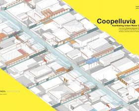
Drylands Urbanism
Within arid and semi-arid urban settings, ALI research focuses on maximizing the recovery, use, and reuse of rain and stormwater, at local and regional scales. Environmental geospatial modeling coupled with fine-grained remote sensing analyses aid in identifying likely sources and quantities of stormwater and may suggest the shifts necessary within land use, public investment, and zoning patterns to maximize these potential resources. Modeling in turn suggests new strategies for distributed infrastructures, localized management, and the urban and architectural forms of a well-adapted built environment.
Stormwater will form an important part of LA's future water portfolio. Current city and county stormwater capture plans focus on stormwater reclamation from publicly-owned land. However, hundreds of More
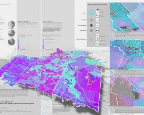
ALI's high-resolution geospatial model maps stormwater as potential groundwater augmentation supply in the San Fernando Valley. The model shows precisely—street by street, lot by lot—where 92,000 More

ALI recently completed a 3-year grant funded by HUD, “Design Assistance for Water-and Energy-Wise Communities.” ALI teams mapped and modeled water imports, embodied energy, and urban stormwater More
